TAILINGS SOLUTIONS
TAILINGS MANAGEMENT
An important step on the repair path involves finding solutions to the tailings that have spread through the Doce River and its tributaries. To seek the best ways, Renova Foundation heard more than 80 specialists. And, based on everything which was exposed, it created the Tailings Management Plan in June 2017.
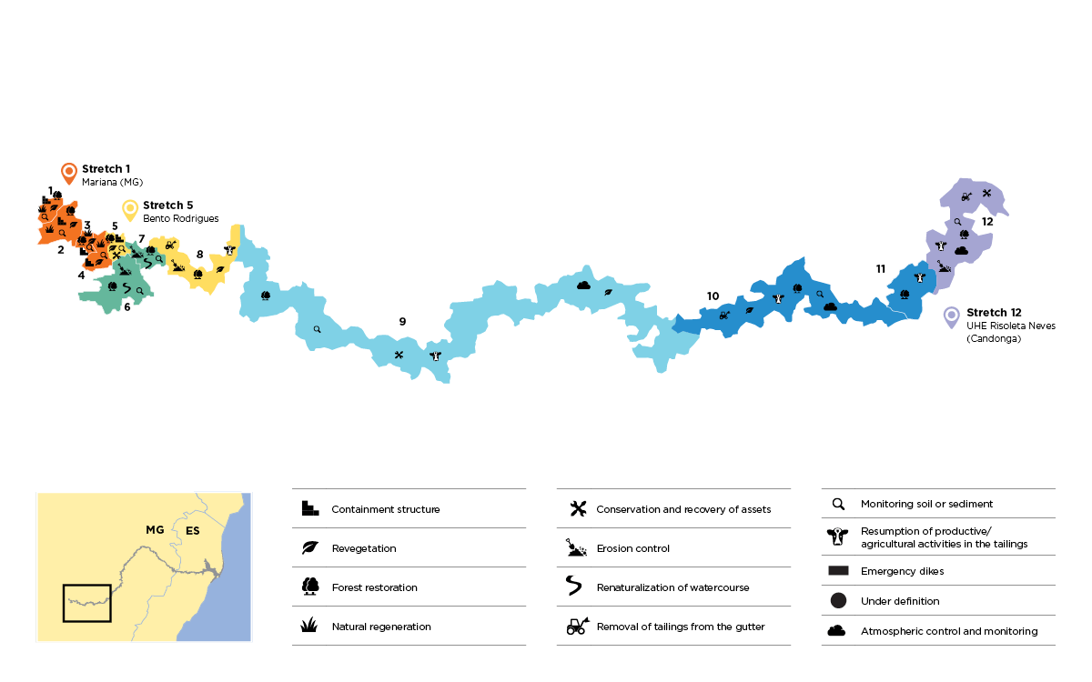
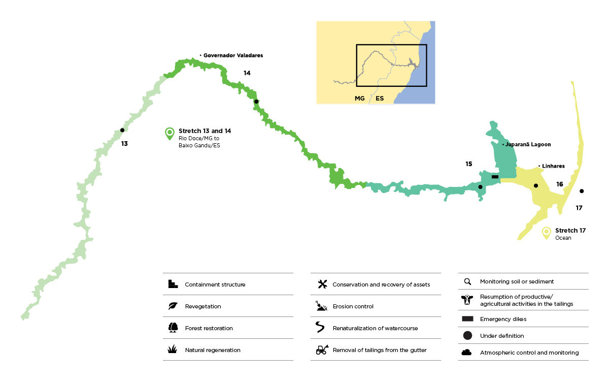
The plan divided the affected region, which covers 670 kilometres, in 17 stretches, from Mariana (MG) to Linhares (ES), at the mouth of the Doce River. Each one is evaluated according to specific indicators. Based on this detailed analysis, the solutions are defined and implemented with the principle of having the least impact on the environment and the surroundings, including communities.
Based on this principle, the Renova Foundation concluded that it would concentrate the actions to remove the tailings from Barra Longa (MG), the only municipality with an urban area directly affected by the mud, and from Risoleta Neves Hydroelectric Plant (Candonga). The other areas would receive environmental and social recovery actions.
ACTIONS FOR REPAIR
The repair actions were initiated shortly after the collapse, with the cleaning of the riverbeds and the stabilization of the riversides of the Gualaxo do Norte and Carmo Rivers, between Mariana and Santa Cruz do Escalvado, in Minas Gerais.
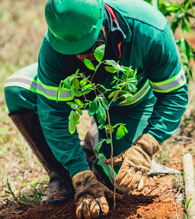
An emergency revegetation was carried out to avoid erosion and, in rainy periods, to avoid this material from going back to the river. The technique also allows the return of the organic matter that the soil needs to restore the vegetation of the riparian forest.

Gualaxo do Norte River was engulfed by mud 15 days after the Fundão dam collapse
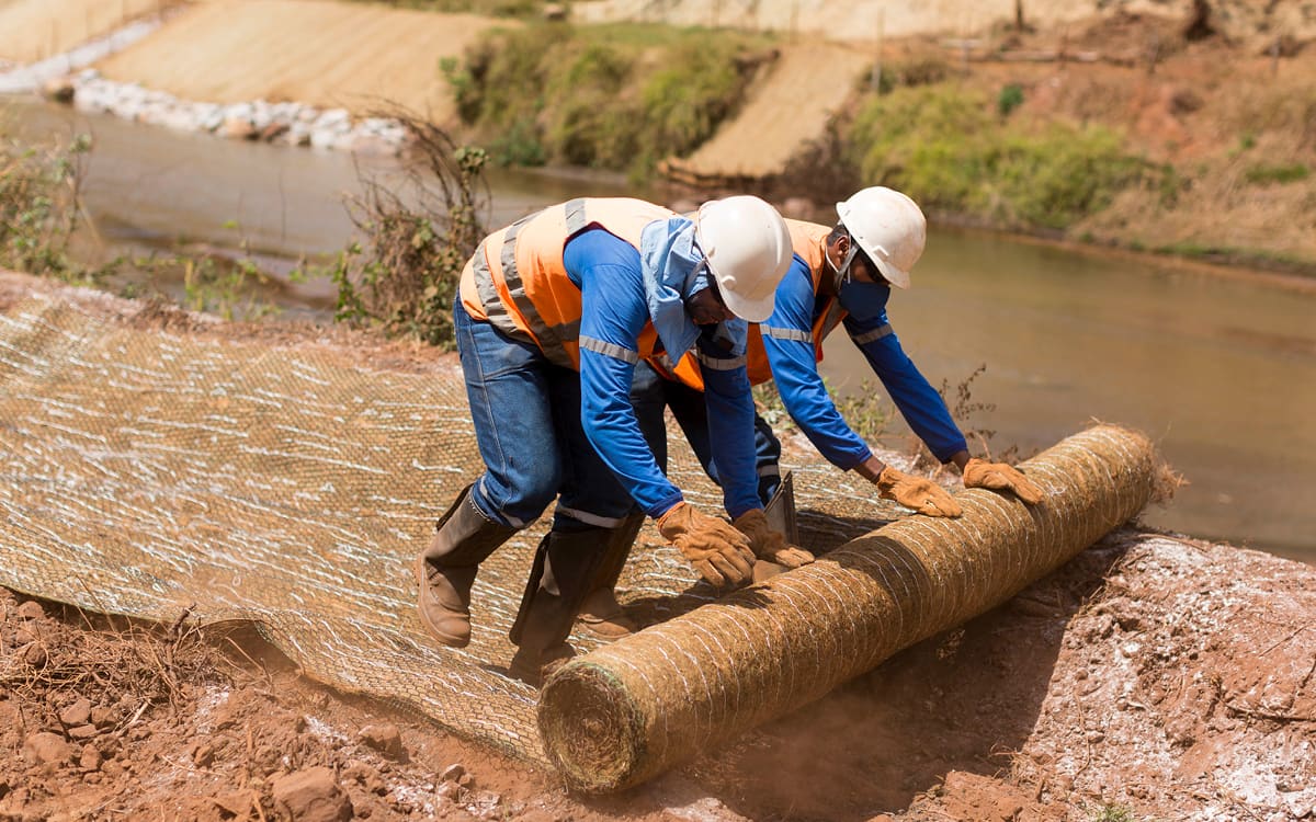
The banksides were restructured using biodegradable blankets

Planting of fast-growing native species helped to combat erosion and prevent sludge from falling into the watercourse.
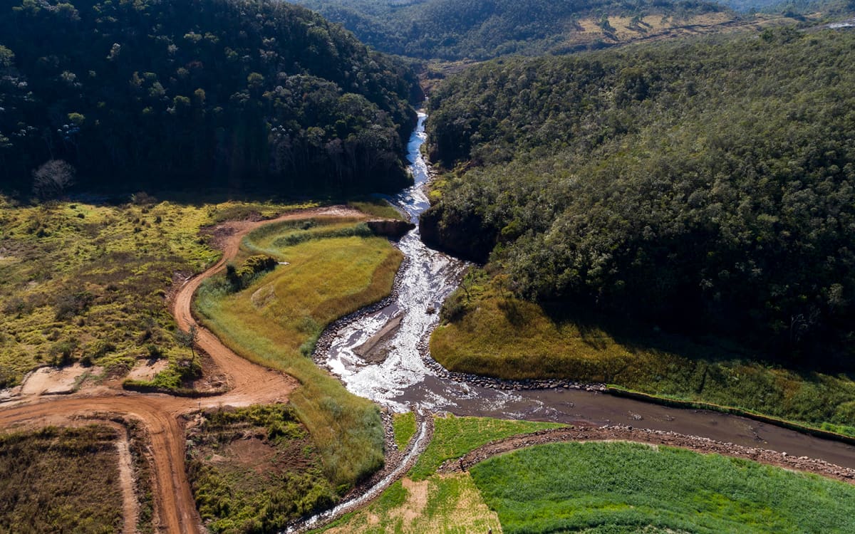
After the emergency stage, Gualaxo do Norte received other interventions such as the riparian forest process of restoration and the renaturalization technique.

The Gualaxo do Norte River, which first suffered the environmental impact, responds to the actions carried out by the Renova Foundation
NATIVE SPECIES
On the banksides and plains of the Gualaxo do Norte River, vegetation is being recovered and enriched with native species.
NATURAL TREATMENT
The Natural Treatment Station (ETN) uses technological solutions to achieve a better standard of water quality. Through the Renova Foundation Economy and Innovation Program, the unprecedented project is being developed by LiaMarinha, a startup from Mariana. ETN uses filtering barriers and islands of vegetation in the river gutter. These barriers are able to filter water and absorb metals.
With the sediment retained, the water that follows will reach the Doce River with more quality and with a lower turbidity index. The station will be deployed after environmental licensing and the first results related to water and biodiversity are expected for February 2021.
CAMARGOS WATERFALL
In response to the request of the Camargos community, district of Mariana (MG), the Renova Foundation will recover the local waterfall, which was used for leisure before the collapse.
A series of meetings was held with residents so they could actively participate in each stage of the process until the conceptual project was approved. The forecast is that the recovery activities of the well and the waterfall surroundings to be completed by the end of the second half of 2020.

RESULTS
The results of the water quality monitoring carried out by the Renova Foundation on the Gualaxo do Norte River show that turbidity is decreasing every year when compared to the end of 2015, in the immediate postcollapse mapping, when turbidity was at its peak.
The river answers
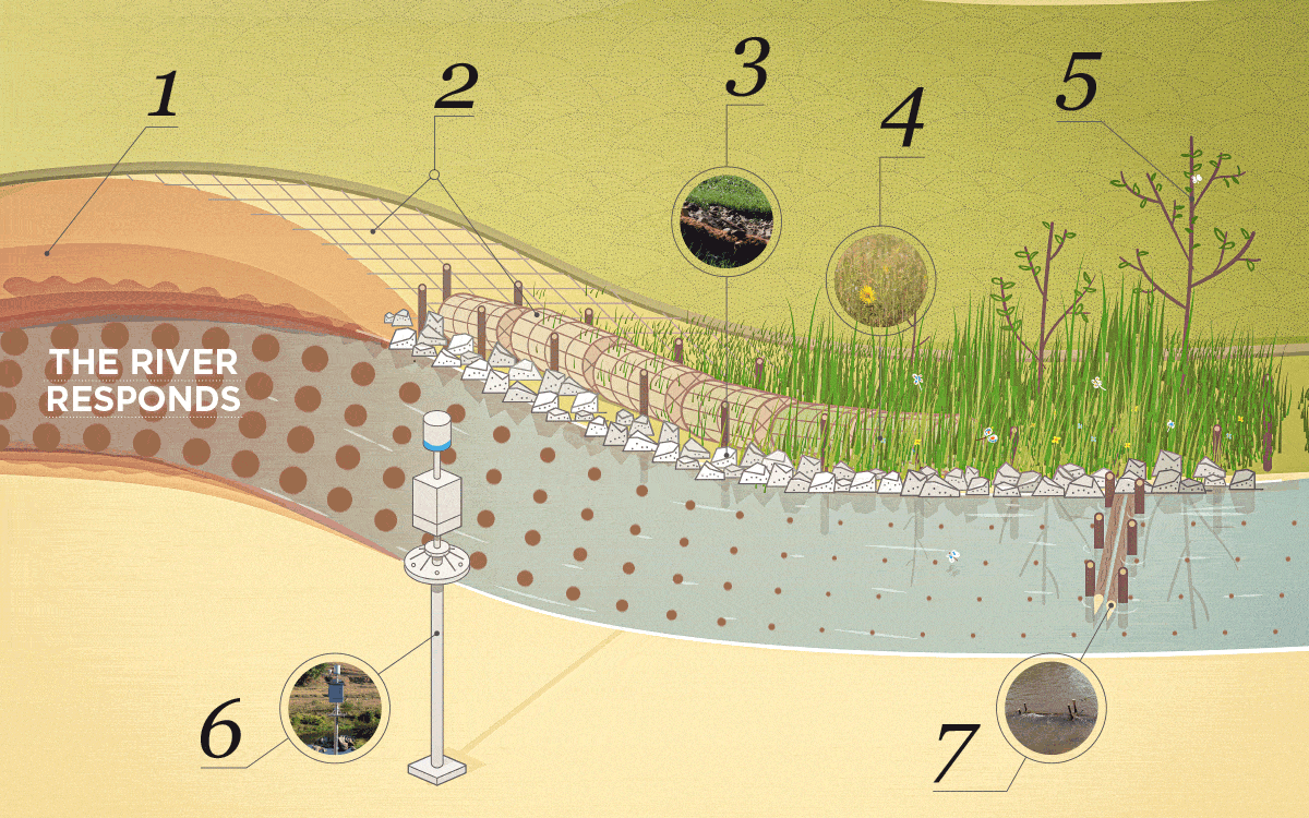
1 – Reconformation
Actions were taken to prevent the mud accumulated on the outside of the rivers from falling into their riverbeds. Among them, the removal of tailings and the planting of fastgrowing native species to combat erosion.
2 – Blankets
In order to restructure the riverbanks, efforts were made to recover them as naturally as possible. For that end, it was placed blankets made with coconut fiber, biodegradable, which also hold seeds.
3 – Rockfill
Another solution adopted was the rockfill, which is to place stones along the riverbeds to avoid erosion in rain seasons. Bermalongas with natural fibers (wooden stakes) are used to stabilize the riverbeds.
4 – Emergency revegetation
Emergency revegetation was carried out with 41 thousand seedlings to avoid erosion and to bring back the organic matter that the soil needs to restore the vegetation of the riparian forest.
5 – Restoration of riparian forest
After the first stages of emergency planting of vegetation and riverbanks reconformation, in January 2018, the riparian forest process of restoration was started, with the planting of native tree species.
6 – Monitoring
The data measured by the automatic stations are locally stored and sent to a database which is accessible by the public agencies that regulate and inspect the Brazilian waters. The results of the water quality monitoring carried out by the Renova Foundation on the Gualaxo do Norte River show that turbidity is decreasing every year, compared to the end of 2015, in the immediate post-collapse, when turbidity was at its peak.
7 – Renaturalization
In order to promote the return of the aquatic ecosystem, the renaturalization technique was used, which creates backwater areas on the riverbank to make it difficult for the tailings to descend and minimizes turbidity.
RISOLETA NEVES HYDROELECTRIC PLANT
One of the areas most affected by the tailings is the region of the Risoleta Neves Hydroelectric Plant (known as “Candonga”), located on the edge of the municipalities of Doce River and Santa Cruz do Escalvado, in Minas Gerais.
The plant played a key role in retaining more than 10 million cubic meters of tailings (a quarter of which leaked from Fundão), preventing them to follow the Doce River channel.
Cleaning the reservoir is a complex operation that started in 2016. Providing the plant the conditions to resume its operation involves innovative and unprecedented engineering solutions.
To contain the tailings mud that could still arrive from Fundão, three metal bars were built inside the plant’s reservoir, where they will be submerged after filling the reservoir.
The cleaning of the plant’s three turbines, called Energy Generating Units (UGE), is completed. This work involved the performance of divers who helped to identify and manually remove the debris that compromised the equipment operation.
The material is dredged and sent, with the support of two boosters sets (pumping station), to two cofferdams, where it is decanted. The liquid effluent is drained into sumps (small dikes) and then sent to basins, where it will be treated and filtered before being returned to the Doce River. With this method, the tailings are dry stacked. The material is accommodated at Floresta Farm, located three kilometres from the plant. Floresta Farm undergoes a series of interventions to receive this material in 2020.
The cleaning at this stage is inside the plant. Among employees and outsourced workforce, the operation has 35 people, in addition to vehicles, dredgers, pumps and other equipment. The works are expected to be completed in 2021.

MONITORING WITH DRONES
One of the most effective technological practices for monitoring the areas affected by the Fundão dam collapse is the use of drones. Held since 2016, the central goal of applying this technology is to quantify changes in vegetation cover and map the improvement in the characteristics of the impacted areas, from Fundão to the region of the Risoleta Neves Hydroelectric Plant.
During different periods, drones capture images with high spatial resolution of the entire impacted region. These images serve as a visual monitoring to see the before, during and after the repair activities.
Its application goes beyond the visual: this material is sent to analysts in geographic information systems, which perform the interpretation of this content, resulting in mapping the use and vegetation cover of the soil.
The captured images generate quantitative data that make it possible to analyze the evolution of the impacted region. For each period, approximately 9.300 hectares are mapped, covering not only the area affected by the tailings, but also the surrounding rural properties, serving as a subsidy several Renova Foundation programs.
Below: Stretch of the Gualaxo do Norte River in Mariana (MG). Visual information helps to define the actions of the Renova Foundation in the region.


